Sunday, September 30, 2007

Enchanted Circle - Red River, NM

The Enchanted Circle ride is a century circle which starts in Red River, NM, and circles around to Taos, Angel Fire, Eagle Nest, and back to Red River. This ride is always the weekend after Labor Day in September. If you are looking for beautiful scenery and some challenging hills, this is the ride for you.

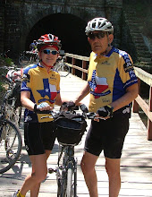
The Sitzmark Lodge on Main Street is usually our home for a few days. The ride normally takes place on Saturday now so we make a little vacation out of the trip. We usually arrive on Wednesday to give us a couple days to get accustomed to the altitude and take advantage of some of the best Mexican food in the area.

There's a short ride up the canyon that is nice with rolling hills. These seem a little more like small mountains since the oxygen is a little thinner in Red River. Another training ride we will do before the 'real' ride on Saturday is to head down to Questa and back. It's downhill for almost 13 miles so that means we have to climb the same 13 miles to get back to town.


On Saturday, we start early in Red River, usually with tights and jackets to keep us warm. We shed some of this by the time we get to the rest stop, 25 miles out, at Arroyo Hondo. From there, we ride another 10-12 miles to Taos where there is another rest stop at the Kit Carson Park. Now it's decision time. Do we try to find a ride back to Red River or do we continue on the trek. Okay, let's continue the ride this year. We'll ride 18 miles uphill to the top of Palo Flechada. We are definitely ready for another rest stop at this point. The next few miles are downhill but be careful, there are some pretty hairy turns on the way down toward Angel Fire.

We'll pass by the Vietnam Memorial as we skip the out and back section of 14 miles going toward Angel Fire Ski Resort and back. This will make our trek only 86 miles but with these tough climbs, 86 miles is plenty. This section is relatively flat but typically straight in to the wind. Once we get to Eagle Nest, we head up toward Bob Cat Pass and then the last 4 miles to Red River will be downhill. It's 17 miles to the top of Bob Cat Pass but the last 2 miles are by far the most difficult. The downhill makes for a nice finish to a long, challenging ride.

Of course, there are things to do here besides cycle. In addition to visiting Taos and a few historical sites, there is the Wild Rivers Recreation Area with some great hiking trails, located just north of Questa.

Monday, July 30, 2007

Cycling the Pacific Northwest

This was a self-supported tour with 4 other couples from our cycling club and our first real cycling tour. We thank Rickey Wray for putting this together, making all the arrangements, and being our tour director for this trip.

We started our trip in Seattle. First thing after breakfast, we rode to the ferry which took us across to Bainbridge Island, one of the larger islands in the Puget Sound. This was our longest day of riding.... 100 miles. Of course, since we were self supported that meant that we could jump in and out of the SAG van at any time. A couple of the guys did ride the full compliment of miles. Others stopped at the lunch stop, Fat Smitty's, while a few of the girls took advantage of the SAG for a while and then started riding again after lunch. Us girls rode parts of the Olympic Discovery Trail until we saw a sign that mentioned a cougar siting. At that point, we called Paul and Brad to come get us. As it turned out, we were tired anyway and another cyclists told us we still had about another 5 hard miles to go before we reached town.

We stayed at the Inn at Rooster Hill in Port Angeles, a B&B we highly recommend if you are in the area. The following day, a couple of the guys ventured up Hurricane Ridge while the rest of us rode the Salt Creek Park loop. We rode along the Little River Road, made a stop of the Joyce General Store, cycled the shoreline, and passed under some WWII bunkers before returning to the inn.

Another ferry ride the next morning to Victoria, BC, in Canada and a short ride to Sidney and the Sidney Waterfront Inn. This was a beautiful ride along the coastline; probably the most scenic of all the days. We had rain the next morning, so we all went sightseeing in Victoria at the Royal British Columbia Museum, had a bite for lunch, and stopped by a local bike shop before returning for an afternoon ride. Our ride took us out to Butchart Gardens. Some of the group toured the gardens. Paul and I had been through them before so we did a load of laundry and then rode out to meet everyone.

We are off for another ferry ride, this time to Orcas Island. There was a lot of fog which put the ferry schedules behind and our SAG was late arriving on the island. Once on Orcas Island we had to ride a short 12 miles in the rain. We stopped in town for some wine, though. Paul carried 3 bottles in the backpack and Brad carried another bottle in his camelback. Do we sound desperate?

Light rain and fog the next morning so we went sightseeing around the island. The afternoon was beautiful so most everyone went for a spin. Everything was very green and just beautiful with little to no traffic and just hilly enough to make you work hard at times.

The next morning we caught the ferry from Orcas Island to Anacortes. Once in Anacortes, it was raining again. Since we were self-supported, our van would hold all of our luggage, 6 bikes, and 6 people. That meant that 4 people had to ride at all times. This was not a problem til today. Paul along with 3 of the other guys rode 60 miles in the rain to Mukilteo; even crossing over Deception Pass. Boy, were they dirty and muddy when they finally arrived.

Our last full day before heading home and we shuttle everyone back to Seattle. We took some time to explore the famous Pike Place Market, took a short ride along some of Seattle's bike trails, then packed the bikes for the return trip home.

We have to give Rickey credit for organizing this trip. He found us great bike routes with low traffic and beautiful scenery. The weather was typical Washington State weather... usually fog and light rain in the mornings with sunshine in the afternoons.

Monday, June 4, 2007

Talimena Scenic Byway

Spanning the highest mountain range between the Appalachians and the Rockies, the 54-mile Talimena Scenic Byway opens a showcase of natural beauty and extraordinary views. Wide valleys and majestic peaks stretching to the horizon mirror the changing colors and moods of the South's four distinctive seasons. One breathtaking panoramic view follows another as this national forest scenic byway winds along the crests of the Oachita mountains between Mena, AR, and Talihena, OK.

Just north of the town of Mena, the scenic byway meanders along the crest of Rich Mountain. Atop Rich Mountain lies the Queen Wilhelmena State Park and the Queen Wilhelmena Lodge which served as our home base for the weekend. Our ride started at the Lodge and went along the byway for 42 miles, making the round trip ride 84 miles. Paul and I both had every intention of cycling the entire 84 miles when we started out. That changed quickly as we started up the first few mountains.

We found ourselves riding over the peaks rather than around them. The hills are steep and include 2 climbs over 1500 ft. We would grind our way up one side and then find ourselves screaming down the other side. The steeper it got and the more we climbed, the more tired our legs were. There is very little traffic on the byway (mostly motorcycles) and what traffic is there usually is taking it slow so they can enjoy the views. It was best to look around and take in the views while climbing in order to take our minds off the constant grinding. Looking straight ahead only showed us the hill we were climbing and sometimes the next hill coming up.

We made it to the lunch stop which was at 40 miles. I stopped at this point and helped with the SAG driving. Paul had lunch and then headed back to see how far he could go. After about 2 miles of climbing the hills, he stopped as well. We headed back to the Lodge, picked up our truck, and went back out to check on the other riders. Some were walking the steep hills while others were still pedaling. The return trip included what's known as 3-mile hill. Yes, you can just imagine what kind of climb this is. On the way down, I remember pulling on my brakes almost the entire time.

Back at the lodge and cleaned up for dinner, the Buffet awaits. Our group met for dinner and reminisced over the days events. We congratulated those who made the entire 84 miles as well as everyone who rode any part of the byway. Let me assure you, this is not a beginner ride. It is one of the most challenging rides we have ever done. And one of the most beautiful.

Even if you don't ride bikes, it's worth the trip just to drive the byway and see the beauty of the mountains.