Saturday, September 18, 2010

Cycling Cape Cod, Nantucket, and Martha's Vineyard - Sept 2010

Bike and the Like has been organizing cycling trips on Cape Cod and the New England area for more than 17 years. They advocate a “stop and smell the roses” type of touring and we have enjoyed their tours immensely. We began our trip in Hyannis, MA, and cycled the nooks and crannies of Cape Cod, including visits to Martha's Vineyard and Nantucket. Cape Cod is known for its miles of glorious coastlines, quaint villages, scenic byways, the Cape Cod Rail Trail, and more.

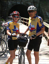
We arrived early in order to get fitted to our rental bikes and took a spin around the Hyannis area, passing the JFK Memorial and nearby Hyannisport, home of the Kennedy Compound. Our first night’s dinner is where we met and greeted the other cyclists on this trip; a total of 39 of us plus 3 tour leaders. And, of course, most of us had lobster for dinner.

The first day of riding with the group took us on a ferry to Nantucket where we cycled the island and walked the cobblestoned streets of historic downtown. Nantucket is located 30 miles off the south coast of Cape Cod and is 14 miles in length and 3 ½ miles wide. With its conservation land, beaches, lighthouses, bike trails, and history, this was a nice day of cycling.

The next couple days were spent on Martha’s Vineyard. We pedaled along the Cape Cod Canal following the Manamet River, stopped at the Aptucxet Trading Post museum, then along the Shore Rd to the Shining Sea Bikeway to Woods Hole where we caught the Steamship Authority Ferry. The ferry brought us to the town of Oak Bluffs where we stayed at the Madison Inn for two nights. Oak Bluffs flourished as a revivalist-movement camp meeting site. Over the years, the tents were replaced by small cottages in the distinctive "campground gothic" style, which makes you feel like you're walking through a neighborhood of pastel gingerbread houses. We explored the town that evening and met the group for dinner.

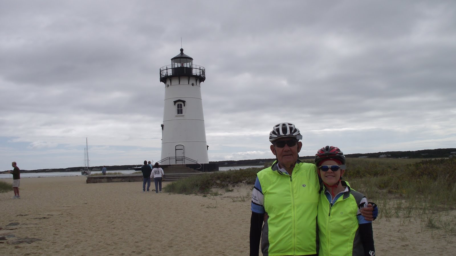
The next day we cycled on the bike trail to Edgartown and the lighthouse (pictured below left) on the north shore. The Edgartown Light made a brief appearance in the movie Jaws. We continued on the bike path around the airport, stopped by an Alpaca farm, lunched in Vineyard Haven, cycled the West Chop loop and lighthouse, around the harbor, on to the East Chop loop and lighthouse, then back to the hotel. As an example of history, the East Chop lighthouse was built in 1802 on Telegraph Hill. The lighthouse is on the site of the signal station that received semaphore messages from Woods Hole to indicate the arrival of homebound whaling ships. The current lighthouse was built in 1877. We took a very relaxing pace today and explored the history of the island.

We took the hi-speed ferry back to Hyannis the following morning and headed to the village of Orleans. Once on our bikes, we cycled the beach roads, stopped and toured the Judah Baker Windmill, jumped on the Cape Cod Rail Trail, passed through Nickerson State Park, took a short side trip to Nauset Beach, and finally rested at the Old Tavern Inn in Orleans for the night. Like much of the Cape, Orleans revolved around fishing, whaling, and agriculture in its early history.

Our next stop was Provincetown. We cycled up the elbow of the Cape via the national seashore. We stopped after about 5 miles at the Salt Pond Visitor Center and watched a film on how the Cape was formed through the ice age….very interesting and well worth the stop. The museum had an old bike on display that had wood spokes. Imagine riding that bike.

Back on our bikes, we cycled the Cape Cod Rail Trail, passing the Nauset Lighthouse and Marconi Station. Guglielmo Marconi had a dream to send a wireless signal across the ocean and, in 1900, he built a high-powered transmitting station to do just this. Storms blew down the aeriel towers in 1901. We stopped in Wellfleet for a short lunch and then continued on around the harbor, along the beach, more lighthouses and windmills, and finally into Provincetown.

Once in Provincetown, we had the evening on our own. We walked through town, climbed the Pilgrim Monument, stopped for a couple drinks and dinner, and made it an early evening. A couple of cyclists who made it in early enough were able to take a whale watching tour. They said they saw at least 30 whales and got some great pics.

It was now time to head back. We left Provincetown cycling through the sand dunes known as the Provincelands, along the beaches, and back on the Cape Cod Rail Trail. Most everyone stopped at the Chocolate Sparrow in Orleans for lunch. Here, we had a turkey pannini and an ice cream cone while others chose to have some “to-die-for” chocolate desserts.

Our last day brought us back to Hyannis where we said our ‘good-byes’ to all our new friends, caught the bus back to Boston Logan airport and flew home.

The only way to really experience Cape Cod is to cycle the “nooks and crannies”. Cape Cod’s terrain is very cycle friendly and mostly gently rolling. There are so many sights to see and places to visit that the only way to do it is on bicycle. We averaged about 45 miles a day and took our time to be sure not to miss anything. If you like mixing sightseeing with your cycling, you’ll love this trip.

To view more photos from this trip, click on "Cape Cod Cycling" under "Links to cycling pics" on the right side of this page.

Friday, August 6, 2010

Colorado 2010

We have returned to Frisco, Colorado, for the month of August. We've been having afternoon and evening showers but have still managed to get in some cycling. We've learned over the years that wherever you stay in Summit County, the bike path will take you through Frisco; whether you are riding to Breckenridge, Keystone, around Lake Dillon, or to Copper Mountain or Vail.

Our first day, we rode up to Keystone and over Swan Mountain Rd back to Frisco. We decided that was not too hard on us so the next day we ventured on and rode up to Vail Pass. Whew! That was a test for our legs in this high altitude. The photo to the right was taken from the bike trail around Lake Dillon.

The next couple days consisted of rides which we had not done before. We drove to Carbondale, 13 miles south of Glenwood Springs, and rode the Rio Grande Trail to Woody Creek Tavern and back. This bike path (pictured left) is actually 42 miles long and goes from Glenwood Springs to Aspen. It is slightly uphill on the way to Aspen which makes for a nice return trip back....downhill.

Our next ride took us to Leadville and around Turquoise Lake (pictured right). This was only about 25 miles but it consisted of several long and challenging uphills and some fast downhills. The scenery was beautiful. We finished just ahead of the heavy rain over the lake. Back in town, we lunched at the Tennessee Pass Cafe which fulfilled its reputation as being one of the best cafes in Leadville.


About an hour's drive west of Frisco is the Dotsero/Glenwood Canyon trailhead (exit 133). Hop on the recreation path which follows alongside parts of I-70 and the Colorado River and ride for about 16 miles into Glenwood Springs. Once in Glenwood Springs, explore the area or partake of the Hot Springs before heading back. Of course, you can always drive the additional miles into Glenwood Springs and start from there. This is a relatively flat trail with only a couple of short climbs near Glenwood Springs. Everytime we have ridden this route, we have seen lots of people kayaking and rafting the river. (Glenwood Canyon ride pictured left)


Other rides in the area that we enjoy include riding to Keystone and going up to the little town of Montezuma, pop. 60. It's a 5 mile climb out of Keystone and a fast downhill back. The most popular ride for tourists is probably Frisco to Breckenridge and back, followed by the ride around Lake Dillon. The new Swan Mtn Rec Path from Summit Cove takes us to the top of Sapphire Point. Once on top, however, we must take the 2-mile steep and curvy road down to the Breckenridge bike path. One of our favorite rides is Frisco to Copper Mountain and on up to Vail Pass; 10 miles slight uphill to Copper Mtn and another 5 steeper miles to Vail Pass. Here we may either ride back 15 miles downhill to Frisco or continue on to Vail Village (15 miles downhill). But beware, the ride back up from Vail Village is challenging to say the least.

Summit County includes the towns of Breckenridge, Frisco, Copper Mountain, Dillon, Silverthorne, and Keystone. There is always something going on in one or more of these towns every weekend and some weekdays. Our first week here, we took in the BBQ at the Summit which was a lot of fun with music, food, drinks, and roasted corn on the cob. On Fridays, we enjoy going to the Dillon Farmers Market for some shopping and, of course, lunch. Frisco has Music on Main on Thursday evenings and a weekend Art & Music Festival once a month. We've enjoyed the Dillon Summer Concert Series on occasion which is every Saturday evening at the Marina. One of our particular favorites has been the Nacho Men. Unfortunately, we will miss their performance this year. Keystone and Copper Mountain have similar events throughout the summer.

Friday evenings in Keystone, the gondola rides to the top of the mountain are FREE. We like anything that is FREE. Of course, we finish the evening with 2-for-1 appetizers (including nachos) and $3 draft beers at one of the restaurants in Keystone's River Run Village. You can also catch the chairlift in Copper Mountain for free during the day. Thursday thru Saturday evenings, the Vail Gondola is FREE.

We are starting our fourth week here and we are just now doing our first hike. The Mayflower Gulch trail begins on an old ore wagon road and may be shared with jeeps and mountain bikers. On a moderate climb through evergreen forest, you see Mayflower Creek and its adjacent wetlands on the left. Soon signs of Mayflower Gulch's beehive mining history appear. After a little over a mile and a half, we see the Boston mine camp (pictured right) which once occupied this splendid setting. Now its ruined log boardinghouse and cabins slowly sink into the meadow.

Later in the week, we hiked the McCollough Gulch trail just south of Breckenridge. This hike was an intermediate hike with lots of waterfalls near the top. A little further up the trail is a calm lake with crystal clear water. Although this hike was only a little over 3 1/2 miles in total, it took us close to 3 hours. Our legs will most likely be very sore tomorrow since we haven't been doing many hikes this year.

We love this part of the country ..... the mountain scenery, the temperatures, the biking and hiking trails, the people, everything. This is a very affordable area for a vacation and there is something for all ages here. We highly recommend it.

On the way home, we decided to take a detour and drive down to the Durango area. On the way, we stopped at the Black Canyon of the Gunnison National Park. The following day we drove to Mesa Verde National Park and toured the Pueblo cliff dwellings. Both sights were well worth the extra time.

Be sure to click on our Colorado 2010 link on the right side of the page for more pics of this year's Colorado trip. And for more about cycling in Summit County and the surrounding areas, check out our Colorado Trip in 2006 in the archives.

Wednesday, June 23, 2010

Kentucky - Ohio River Rendezvous - June 2010

The Ohio River Rendezvous is not a sponsored ride. This ride is put together by Jack and Pat Deacon in Kentucky every year. Jack helped us with some of our routes last year and invited us to join his ride. It represents a group of cyclists enjoying the Kentucky backroads and the camaraderie of great friendships. This year, there were more people from out of state than from within Kentucky itself.

We gathered in Lexington on Wednesday night to meet the whole group and have dinner at Transylvania University. What a group! There were a few participants that were unable to make the dinner but, still, there were about 40 of us there.

Thursday morning, there was a ride out of Versailles along backroads and large horse farms. Beautiful countryside!! Unfortunately, we had to miss this ride. We had truck problems as we arrived in Lexington so we spent the morning getting the truck towed to the shop and locating a rental car for the next few days. We did, however, manage to meet some of the riders at Wallace Station for lunch.

The real ride started Friday morning out of Paris, KY. We loaded our luggage in to the SAG vehicles, readied our bicycles, and we were off. The further north we rode toward Maysville,KY, the hillier it became. Kentuckians may have called these hills 'rollers' but for us Texans they were hills. We couldn't roll the hills and didn't have enough time between hills to recover before we were climbing the next one. We were left with very tired legs by the end of the ride.

Saturday, Day 2, took us from Maysville,KY, to Portsmouth,OH. The first five miles were hilly and then we hit a long downhill and followed along the river, more commonly known as the bottom lands. We heard thunderstorms were headed our way and we could see the black clouds in our mirrors; we got a few sprinkles but no rain. The last half of the route today had some long climbs and a few really bad hills. Sixty three miles later we reached the hotel and rested our legs before dinner.

Day 3 (Portsmouth,OH, to Morehead,KY) started out with a heavy fog which we figured was due to being along the Ohio River. This first section was relatively flat and fast. We rode more of the bottom lands and then had two really long, steep climbs. The first bad one was 2.4 miles long at a grade of 8-10% and the second one a little less than a mile but it reached a grade of 19% toward the top. Several people walked part of this hill. We stopped and visited with some people on the way up but we didn't walk any of it. Today we passed many photo opportunities of old barns and farm lands but didn't stop to take a single picture. Guess we were just concentrating on getting over the next hill. Going in to Morehead,KY, we stopped at Dairy Queen for fries and a blizzard before continuing to the hotel. Several other riders joined us there.

Our last day returned us to Paris,KY. Our legs were stressed and this was to be the hilliest day of the tour. We had a couple long climbs and a few hills starting out, turning in to rolling hills for the second section. We passed a lot of covered bridges today. Half way in to the ride, we rode more rolling hills and it was starting to get hot. The last leg was even more challenging...hills, hills, and more hills. We made it back to Paris, loaded our rental car, said our goodbyes, picked up the truck from the shop, returned the rental car, and headed back to Ohio.

We rode a total of 240 miles over 4 days and enjoyed every pedal stroke. This was a great way to tour a part of Kentucky we would not have otherwise seen. Jack and Pat put together a fantastic tour including great SAG support. This was a great bunch of cyclists and we look forward to cycling with them again.

Tuesday, May 4, 2010

Great Allegheny Passage and Chesapeake & Ohio Canal Towpath - May 2010

The Great Allegheny Passage (GAP) trail runs 132 miles through the heart of Pennsylvania, from McKeesport, just outside of Pittsburgh, to Cumberland, MD. The GAP trail connects to the 185 mile long Chesapeake & Ohio (C&O) Canal Towpath which runs along the Potomac River from Cumberland, MD, to Washington, DC. Together, the GAP and C&O Canal add up to over 300 miles of trails.

We were invited to join nine of the ROMEO’s (Retired Old Men Enjoying the Outdoors) to cycle the GAP and C&O Canal the end of April 2010. This was a ride for hybrids and mountain bikes; definitely not skinny tire road bikes. The trail surface was a mix of hard packed dirt, crushed limestone, rocks, gravel, and a few miles of paved path. At times, we found ourselves dodging potholes, tree limbs, and low hanging branches. We even had to maneuver over and around a few downed trees. Including the miles we cycled to and from our lodging each day, we rode a total of 342 miles over 5 days.

We awoke our first day to freezing temperatures so we held off our start until about 9:00am. Bundled up, we gathered ourselves in the van and headed to the McKeesport trailhead, 14 miles out of downtown Pittsburgh. The path was fairly smooth with a slight incline which followed alongside the Youghiogheny (Yock-uh-gay-nee) River. We stopped about every 15-20 miles with our first stop in West Newton, PA. As we cycled on, the temperature warmed and we found ourselves switching from our heavier jackets to light wind jackets. By the time we reached Ohiopyle, about 60 miles, the winds picked up and it got down right cold again. From here, we passed bridges, waterfalls, and timber footpaths on the way to Confluence and the Stepping Stone Farm B&B where we stayed the night.

Again, we awoke to freezing temperatures the next morning. Wearing our winter gear, we rode from the B&B to the trail and continued along the GAP trail. Other than freezing at the start, this was a fairly uneventful morning. We stopped in Meyersdale, PA, for lunch. Cycling the last 8 miles uphill to the high point in the trail brings us to the Eastern Continental Divide, which separates the Chesapeake Bay and Gulf of Mexico watersheds. Ahhhh! Now it’s downhill the rest of the trip. The average grade of the trail never exceeds about 1% except for this next section down to Cumberland which is about 2%. As we started downhill, we passed through the Big Savage Tunnel, crossed the Mason-Dixon line from Pennsylvania into Maryland, then it was 20 miles straight in to Cumberland, MD, where we stopped for the night and the GAP trail ends.

Our third day starts directly outside our hotel on the C&O Canal Towpath. Temperatures were cool but warmed up quickly. The trail follows the Potomac River all the way to Washington, DC. The C&O trail was rougher than the GAP trail. In fact, full-suspension mountain bikes might have been better than our hybrid bikes. We started dodging potholes, tree roots, and large rocks on this section as we passed numerous aqueducts and locks. At times, the towpath surface devolved into a two-track with a grass strip lining its middle. Twenty eight miles later, we reached the famous Paw-Paw Tunnel, a 3,118 ft long canal tunnel which was built to bypass the paw-paw bends, a six mile stretch of the Potomac River. Construction on the tunnel began in 1836 and completed in 1850. Once in the tunnel, we could barely see the light at the other end so be sure to take a good headlight. With the canal wall on one side and a wooden rail on the other (with a big drop off to the canal), it was a little scary riding the bumpy trail in the dark. After clearing the tunnel, we stopped for lots of photos. Then, we cycled on to Bill’s Tavern in Little Orleans for lunch, then headed to our hotel in Hancock, MD, at the foot of the Appalachian Mountains.

Paul had a cut tire from the rocks on the trail so we started the next day at the C&O Bicycle Shop getting a new tire. We then headed out on a very smooth, paved path for the next 12 miles to Fort Frederick State Park where we regrouped and toured the fort and grounds. Fort Frederick was erected in 1756 during the French and Indian War. Back on the towpath we began dodging rocks, potholes and tree roots again, in fact, we wondered why anyone would take a nice packed dirt road and dump truck loads of rocks on it. But, we continued on. We passed more aqueducts and locks, saw families of geese, turtles, rabbits, and a variety of birds. The geese were very protective of their babies and hissed at us as we cycled by. This was our hottest day….temperatures reached a record setting 93 degrees. We finally made it to Harpers Ferry, WV, where Maryland, West Virginia, and Virginia all come together. There was no place for the van to pick us up so we had to carry our bikes up a spiral staircase to cross the pedestrian/railroad bridge in to town and then it was uphill to the hotel.

Our last day of cycling took us from Harpers Ferry all the way to Alexandria, VA. Our first stop today was at White’s Ferry. The General Jubal A. Early Ferry transports eight cars at a time across the Potomac and is the only remaining ferry on the river. The next 20 mile section to Great Falls, VA, was the roughest and slowest section of the trail. Rocks, rocks, and more rocks on the trail. Great Falls had magnificent views of the Falls of the Potomac, Mather Gorge, and Patowmack Canal locks. After a BBQ sandwich lunch and viewing the falls, we continued to Georgetown, the end of the C&O Towpath. We climbed some more stairs carrying our bikes, crossed the Key bridge, and cycled the paved bicycle path about 8 miles to Alexandria where our van picked us up and took us to our hotel. This section of bike path was very picturesque with views of the Capitol, Washington Monument, and Lincoln Memorial in the distance. We had a nice dinner at Gadsby’s Tavern in town and I think we all slept like babies that night.

We awoke to light rain the next morning so we cancelled our ride we had planned to Mount Vernon and, instead, took the metro to the mall area of D.C. where we visited a couple of the Smithsonian Museums and walked to all the monuments; Washington Monument, World War II Memorial, Vietnam Veterans Memorial, Lincoln Memorial, Korean War Memorial, and the Franklin Delano Roosevelt Memorial. Well, we didn’t cycle any miles on the bike this day but we covered miles and miles on our feet.

This was a great trip. We had a couple of extremely cold mornings, warm to hot afternoons, and no rain until the last day. Overall, we couldn't have asked for better weather for this trip. We cycled between 62 and 75 miles each day which took us anywhere from 5 ½ - 6 ½ hours pedaling time. Including our rest breaks and numerous stops to take photos, we had a full day of cycling every day. We burned a lot of calories and ate a lot of really good food.